Directions to Balch Park, Hidden Falls & Moses Gulch Campgrounds
From Bakersfield, head north on Highway 99, take the Porterville exit just outside of town, and follow Highway 65 for 42 miles to Porterville.
Just as you enter Porterville, take the Lake Success exit and drive 19 miles east on Highway 190 past Lake Success and through the town of Springville.
One mile east of Springville, turn left onto Balch Park Road at a corner marked by a large white barn. Continue another three miles and turn right on Bear Creek Road. At this point, Balch Park is only 15 miles away, but the road is narrow, steep, and winding.
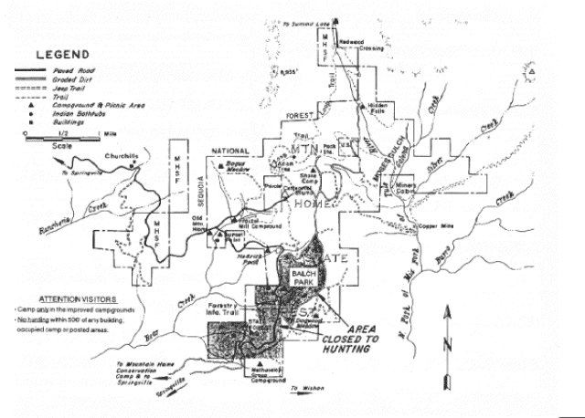
There are two ways to get to Hidden Falls & Moses Gulch. The easiest is a well-marked dirt road that is encountered about 1/2 mile before reaching Balch Park. This dirt road leads 2 or 3 miles to a double junction that can be a little confusing. Turn right to go to Hidden Falls and Moses Gulch, whereas continuing straight ahead leads to Shake Camp. About 2 miles from the confusing junction, another junction is reached. Going left leads about 1/4 mile to Hidden Falls, going right leads about 1/2 mile to Moses Gulch.
The second way to Hidden Falls and Moses Gulch is longer, but passes by the Indian Bathtubs (Sunset Park) archeological site, as well as several notable Giant Sequoias. Continue on the paved road past Balch Park for 2.3 miles and make a very sharp turn to the right onto a paved road, which leads uphill about 1/2 mile to the Fraiser Mill Campground (46 sites). Continue another mile or so, past a Sequoia grove with the Hercules Tree, to a T intersection 1.7 miles from Balch Park Road. Go left at the T intersection then make an immediate right at a Y intersection.. (Going right at the T leads back to Balch Park, and going straight at the Y (left) leads to the Balch Park Pack Station and Shake Campground).
Stay to the left at a turnoff to Moses Gulch, and the gravel parking lot for Hidden Falls appears about 2.6 miles past the confusing T-Y intersection, and just before the road crosses a creek. There are eight walk-in sites along the creek, with the furthest site located several hundred yards downstream.
|