|
SUMMARY: A 25-mile roundtrip hike that is the standard route to the top of Mt. Whitney. Packs must be carried about 20 miles of the total distance. Allow 3 to 4 days for the trip.
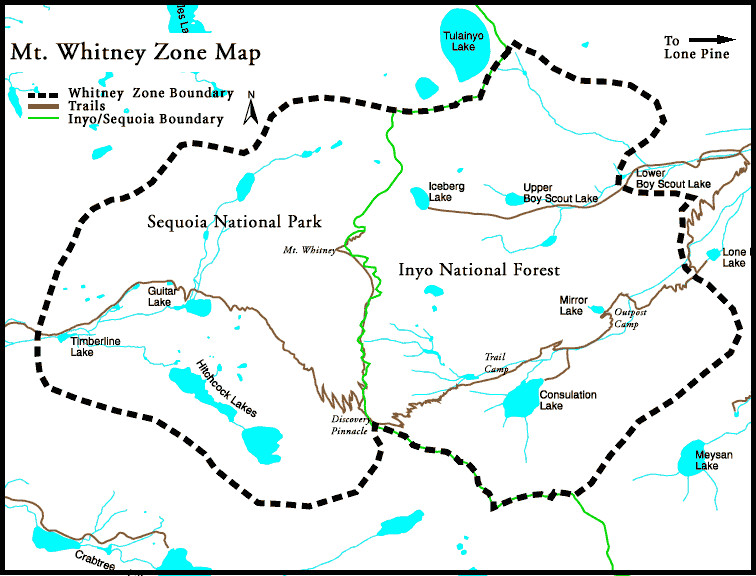
DESCRIPTION: The Mt. Whitney trail is a steep and rocky trail, with many switch backs, which starts at the upper (west) end of Whitney Portals Campground. It passes above Mirror Lake and continues up to Trail Crest. The camping at Mirror Lake is fair, with no fires allowed. Camp is best made higher up at Outpost Camp above Mirror Lake and before a series of over 90 switchbacks that lead up to Trail Crest. Above, the trail turns north, ˝ mile from the Trail Crest, and proceeds along the west sides of Mt. Muir, Day Needle, and Keeler Needle, becoming steeper ˝ mile from the summit. The trail then gradually levels off as the stone shelter hut at the top becomes visible. (Do not take refuge in this hut during lightning storms. Several hikers have been fatally electrocuted here by lightning strikes). There is no water on top, and packs may be left, off the trail, at the Mt. Whitney Trail junction. The views of Owens Valley are excellent both on the way up and on the summit. MAPS NEEDED:
|
| Copyright © 1999-2011 - Southern Sierra High Adventure Team |